ShackDeck Sign in Download Free Now

What's new

Every new feature of ShackDeck, as it ships.

Weather charts by fax, APRS on the map, meteor scatter 14 October 2026

ShackDeck now decodes the DWD weather fax on 3855, 7880 and 13882.5 kHz, shows APRS stations and weather on 144.800 on the map, and decodes MSK144 meteor scatter on 6 m, 2 m and 70 cm.

ShackDeck: a weather chart received by fax, Canadian Ice Service via DWD

Three decoders arrived in one build.

Weather fax. The German weather service broadcasts surface analyses, forecasts and ice charts by radio fax several times a day. ShackDeck catches the start tone, finds the phasing, measures the line period so the chart never leans, picks up a chart that has already started, and ends the picture on the stop tone. The chart fills the window as it arrives, two lines a second, and the schedule of the next transmissions is in the station card.

APRS. On 144.800 MHz the program decodes position packets, objects and weather stations and puts them on the map with their symbols; weather stations show temperature and wind. Every packet is listed under the waterfall.

MSK144. Meteor scatter on 6 m, 2 m and 70 cm: short bursts reflected from meteor trails, decoded the way the FT8 decoder does it, with every station on the map.
Satellites: passes, Doppler, the ISS and Starlink trains 13 October 2026

A new tab tracks amateur satellites, the ISS and weather satellites over your location, with passes for the next day, azimuth and elevation, Doppler-corrected frequencies and a map of the footprint. Starlink gets a group of its own.

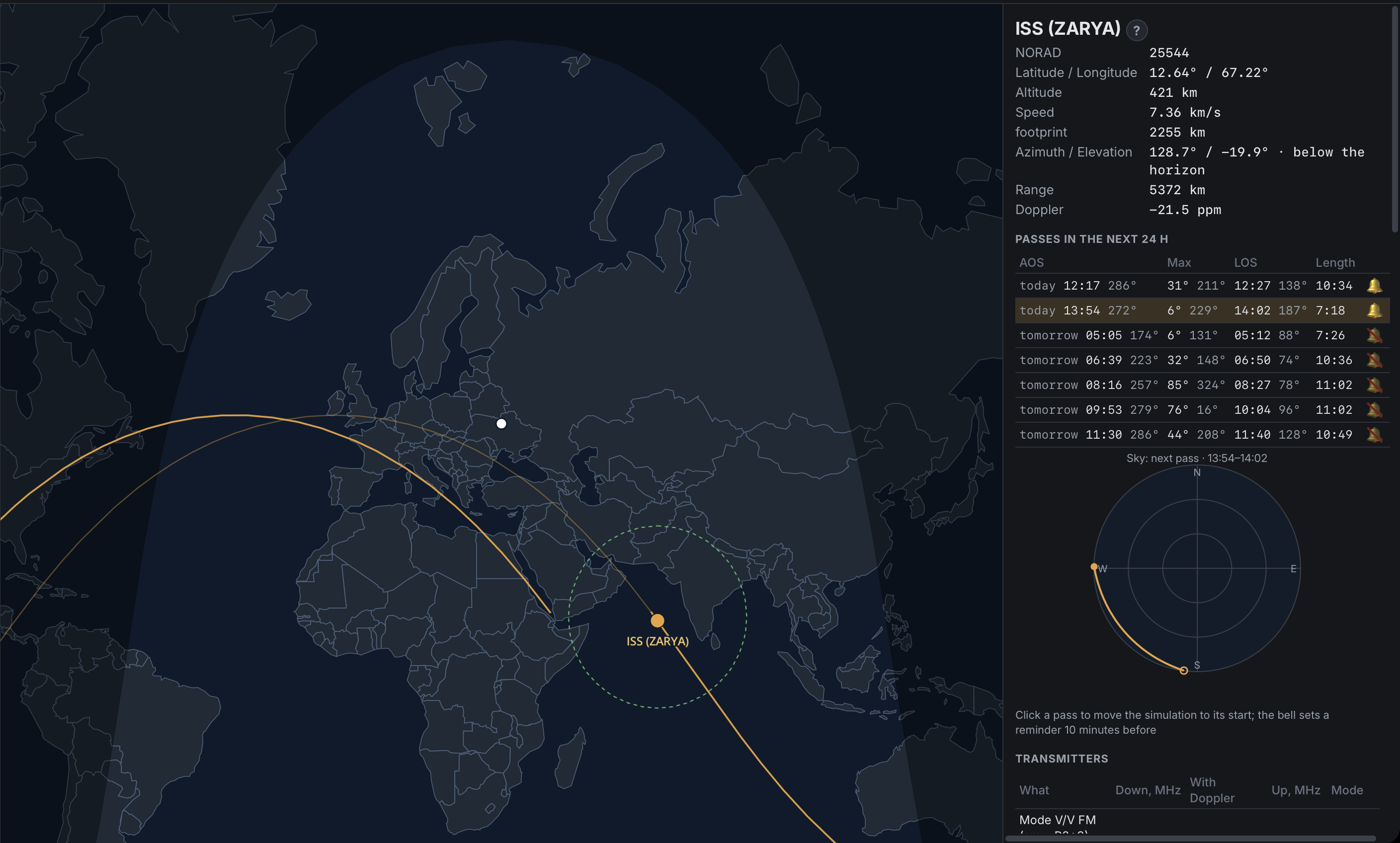
The Satellites tab: the ISS over the Indian Ocean with its track and footprint, the passes for the next day and the sky view

The Satellites tab answers the question every satellite operator asks first: what is over me, and when is the next pass.

Pick a satellite from the groups (amateur, ISS and stations, weather) or search it by name or NORAD number. The program shows where it is right now on the map with its footprint, and lists the passes for the next 24 hours with the rise, the maximum elevation and the set. Azimuth, elevation, range, altitude and speed update live. A sky view draws the pass as you will see it from your locator.

The transmitters of each satellite are listed with their downlink and uplink, and next to the nominal frequency stands the frequency with Doppler applied for this moment. When a public receiver covers that frequency, a Listen link opens it and keeps the Doppler correction while the satellite is over you.

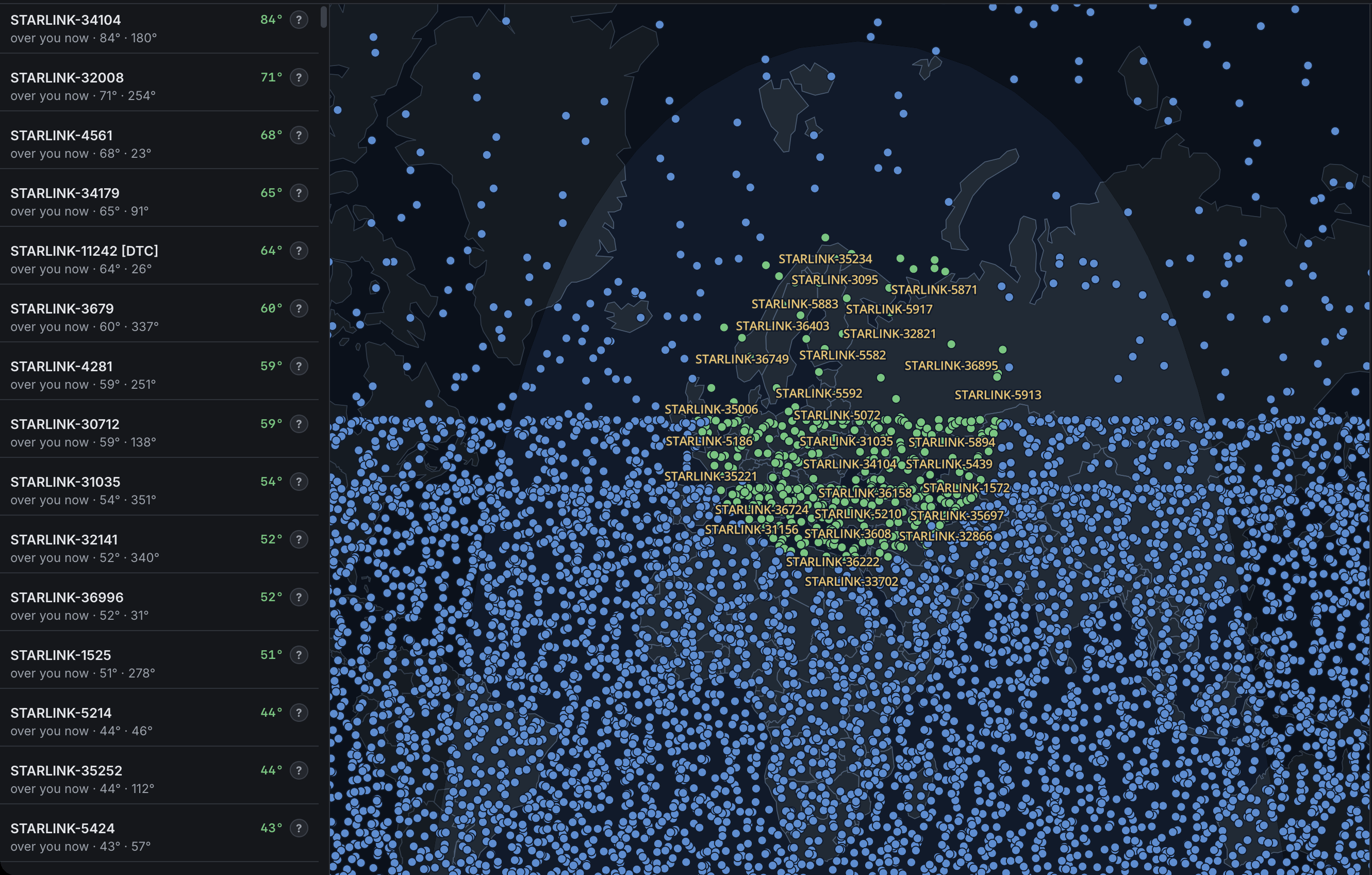
Starlink has its own group: ten thousand satellites that would blanket the map, so they are left out of "All" and shown only when you ask. After a launch the trains are a sight worth a look.

Starlink: the whole constellation on the map, the satellites over you in green

The Starlink group on the map: the satellites above you are drawn in green with their names, the rest of the constellation in blue.

A reminder ten minutes before a chosen pass, a chime at rise and set, a clock you can run forward to plan an evening, and five looks for the map: scheme, imagery, streets, night Earth and relief. Orbits come from CelesTrak and are cached, so after the first load the tab works offline.

ShackDeck 0.1: public receivers, decoders and a logbook in one window 12 October 2026

The first build: hundreds of public SDR receivers with a real waterfall, FT8, FT4, WSPR, RTTY, PSK31, SSTV and CW decoders, and a logbook with ADIF, callsign lookup and a map.

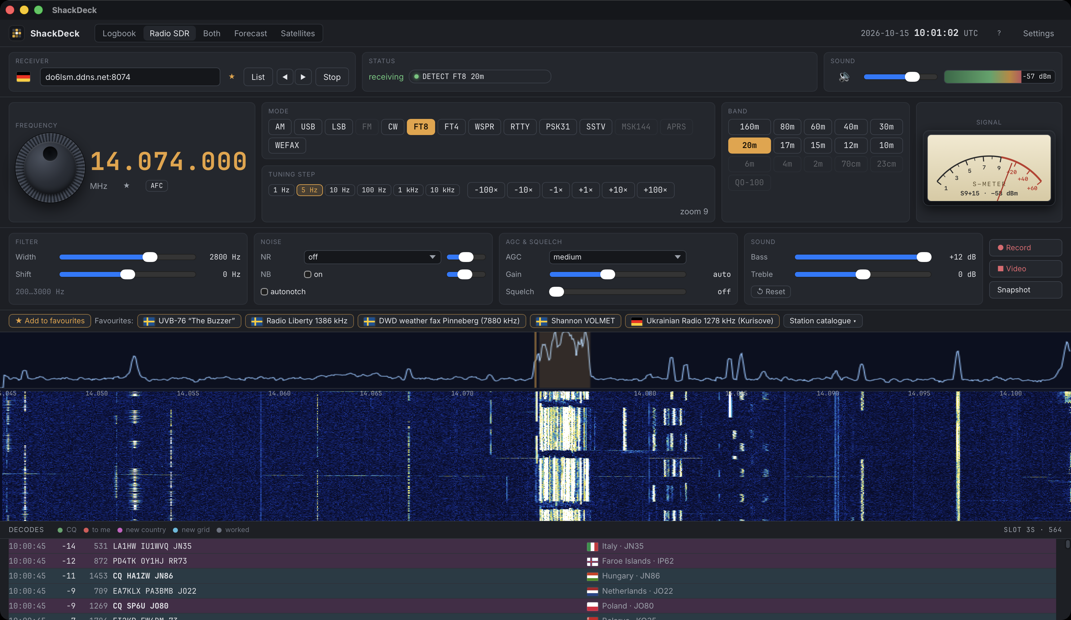
ShackDeck: the receiver on 20 m FT8 with the waterfall and decodes

The first public build of ShackDeck does three things that usually take three programs.

Listen. The receiver list holds hundreds of public KiwiSDR and OpenWebRX receivers around the world. Every one is checked by a real connection before it is shown, so the list contains only receivers that answer right now. They are sorted by distance from you, and each has a flag and a place. Pick one and you get a waterfall, a tuning knob, a passband and the usual modes.

Decode. FT8, FT4, WSPR, RTTY, PSK31, SSTV and CW are decoded inside the program, on the audio that comes from the receiver. Every decoded station lands on the map and in the on-air table. If you wish, the decodes go to PSK Reporter under your callsign; that is off by default.

Log. The logbook takes contacts by hand or from the decoder, imports and exports ADIF, looks callsigns up on QRZ.com or HamQTH with your own account, follows a DX cluster and draws worked countries and grid squares on the map.

macOS 12 or newer on Apple Silicon. Free.